Photo Gallery
Huthwaite Addressing
Sutton Rd Bottoms
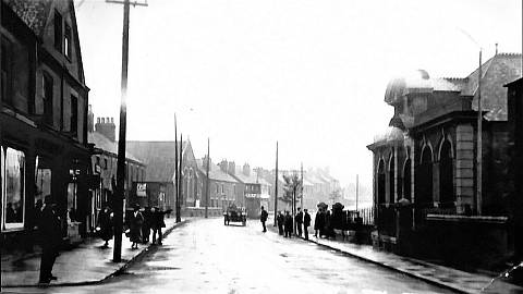
Picturing full length of Sutton Road begins with highest numbered Huthwaite premises from junction into Market Street. Earliest scenes look eastward up the through road, where the later designated B6062 extends back towards its other named destination as Blackwell Road. The shops and housing here date from circa 1888, far predating one smaller central block plus a facing library.


This entire section up towards a Wesleyan Chapel would long after be locally known as "The Bottoms". Exact reason why seemed to have been long forgotten, leaving just one explainable presumption, that it does simply represent lowest section of Sutton Road. However, clues helping explain real reason are found behind the naming of Old Fall Street and New Fall Street. The Falls once spanned an area of natural water drainage, flowing off its Top End above Main Street and dropping across this Hucknall Lane.
Clearing away older premises once cornering top of Columbia Street leaves the later built library exposed at far end that side of Sutton Road. Highest even numbered dwellings thereafter end aside the shown field before claiming a Huthwaite Welfare Park.


Further juxtaposed coverage of The Bottoms Shops will reveal numerous changes since Woodhead & Sons first claimed that end corner. Most of these odd numbered premises would all date from around same 1888 year the colliery built houses named their Prospect Place. My great great grandparents must have been among earliest tenants, because mothers grandfather Arthur Stones was born there in June 1889. In fact Jacob and Ellen Stones did actually give their certified addressing at The Bottoms.

Continuing this eastward route from Huthwaite identifies the next section leading beyond an historically recognised Tram Terminus. Asserting that 1906 landmark manages to look back along the Bottoms, best exposing the Primitive Methodist Chapel. Additional shops cornering and blocking sight into New Fall Street are further revealed in one of Lakin's historically titled postcard scenes.
25 Jan 13 by Gary Elliott Updated 14 Nov 19


