
A Hucknall History
The Huccan Hahl Hundred
This is based on qualified research by Dr W K Grant, who was invited by Roy Peters to look into his local interests. Publication in The Ashfield Historian Vol IV November 1996, aimed to support another matter. Simplified explanation focuses on his accepted data..
Revealing a Hucknall District
Significant identity now gives agreed spelling of Hucca, as the person generally accepted claimed his nook or corner of land, when translating Hucknall from original spelling of huccan hahl. Voicing personal conclusion Hucknall referenced a larger district that included Hucknall Huthwaite, it transpires a Professor Ekwall claimed wider credit offering that concept. Captain Peters managed to later help actually reveal how occurrence could have begun before inviting Dr Grant in 1995, as an American scholar enjoying a sabbatical researching Domesday England, to look further into ancient studies. Together agreeing substantiated interpretations, they opened profound implications also towards understanding local Anglo-Saxon history, by following the quoted hypotheses.
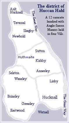
1) That huccan hahl was a district which included the settlements later named Ault Hucknall, Hucknall-under-Huthwaite and Hucknall Torkard, as well as others.
2) That the district of huccan hahl was a single political entity, originally under the control of an Anglo-Saxon chieftain or sub-chieftain called Hucca.
3) That in the course of time the district became formalised into a 12-carucate hundred which, with modifications after the Norman Conquest, can be traced in the Domesday record.
To suppose a district indeed existed its extent and political entity must be determined. Obviously wanting inclusion of Ault Hucknall to the north and a southern Hucknall Torkard it presents a minimum coverage stretching about ten miles. Between those localities finds where Hucknall Huthwaite centrally stands, recording the highest point in Nottinghamshire. Watnall to the south of Hucknall must, as its name suggests, hold recognition being a corner held by someone else, thus representing a southern boundary.
Determining the borders for east and west offered greater difficulty A strong combination of geological and sociopolitical facts gave strongest clues. Incorporating our village and sharing its county division a west line follows long great scarps with gentler slopes eastward into Nottinghamshire. Steep dips west overlooking Derbyshire could well appear cornering an important medieval military significance. These probable boundaries defining north, west and southern extremes additionally claim overlooking stream lines. A good probable east boundary was presented by an ancient road, where the Great Way passed through Ashfield.
Path along the Great Way had been better studied crossing Yorkshire showing a route predating formation of Anglo Saxon estates, between which it formed a complete linear boundary. Factual evidence revealed similar treatment here where 1232 Sherwood Forest perambulation indicated a road boundary quoted enters the district of Newboundmill Bridge, becomes Dawgates to Skegby, Forest Road to Eastfield Side, where it separates Sutton from the forest, thence via Blackmires to the site of Newstead Hospital, and from there south to Papplewick. The section through what is now Newstead Abbey grounds was closed in 1764 when, on the promotion of Lord Byron, a new road was made from Larch Farm to Red Hill.
Having determined possible boundaries enclosing huccan hahl, known references to 12-carucate hundreds offers probable type of governed district. These differed from hundreds better identified since Domesday, which formed later and differently as county districts, including our past Broxtowe Wapentake.
The 12 Carucate Hundred
Apparently the word carucate derived from Latin for plough was originally a land measure. An area conceived sized upon ability for a team of eight oxen handling one plough. That had approximately been considered enough to sustain a manorial family, probably with dependent workers. Consisting eight bovates incorporated by earlier medieval districts it later fossilised as a taxation unit, illustrated after manor sizes drastically reduced.
Dr Grant qualifies evidence behind that previous taxation method existing, quoting Phillimores Domesday translations between sections dealing with counties mentioned. SHIRE CUSTOMS - In Nottinghamshire and Derbyshire, if the King's peace, given by hand or seal, be broken, a fine is paid through the 18 hundreds, each hundred £8. The King has two parts this fine, the Earl the third;
ie 12 hundreds pay the fine to the King, six to the Earl.
Showing antiquity already as a past custom is also indicated referencing the Earl taking part payment, there being no such titled presence by 1086. Calculating those fines confirms implications towards holding a 12 carucate hundred with explanation that £8 was 12 marks or 120 Danish ora, the number referred to as a long hundred. Taking 10 ora as one mark per carucate, fines equate down to 0.125d pennies per bovate. Containing only 18 such hundreds suggested to the author an unusual trait. The total measure of 216 carucates represents a mere fraction to overall size of these two midland counties. Fining then demonstrates an unfair punishment placed upon innocent parties paying for sins of the guilty. A system suggesting particular sensitivity, which he could only justify if the Kings peace held specific importance among these designated divisions.
From earlier 18 divisions only 3 hundreds gained actual mention under Nottinghamshire entry. Blidworth, Southwell and Plumtree appeared but others were indicated. These recognised hundreds generally subdivided into four vills. Each of those sub-units measured 3 carucates or 24 bovates. Full calculations must confirm inclusion of all relevant areas deduced from known data.
Dr Grant claimed to find undeniable detailing which would allow ruling out earlier misconceptions laid by local scholars. Stating Peters even held initial reluctance modifying his figures before producing this district layout probably ruled by Hucca. Holding no Domesday identity Hucknall Huthwaite lay within Suttons parish lands, then ruled from Mansfields larger manor. The other small area Ault Hucknall crossed county borders also defying any inclusion. Referencing Ault Hucknall today in Derbyshire became dismissed as irrelevant by this author. Plausible explanation reads attempts are to reveal a situation before our familiar midland counties were even defined. Records in Domesday actually set situations understood in 1086, but also a previous picture is offered showing changes affected tempore regis Edwardi, ie in the time of King Edward.
Dividing 96 bovates into 4 equal vills.
Listing Nottinghamshire actually claiming two Hucknall entries, had been believed both applied to just Torkard. Under light of progressive findings it was becoming apparent reference could include one of the two northern Hucknall areas now under consideration.
LAND OF RALPH OF BURON - In Hucknall Ulchet had 12 bovates of land taxable. Land for 2 ploughs. Osmund, Ralph's man, has 1 plough and 5 villagers who have 3½ ploughs. Woodland pasture 1 league long and ½ wide. Value in time of King Edward 30s, now 15s.
Connecting Ralph de Buron with Hucknall Torkards well known Byron family gave clue to identifying that area. Dr Grant clarified this providing calculations showing those fertile and productive Buron lands.
LAND OF WILLIAM PEVEREL - In Hucknall two brothers had 4 bovates of land taxable. Land for ½ plough. 3 villagers have 1 plough. Value in the time of King Edward, 8s, now 4.
Re-assigning these remaining bovates could heavily support Peverel lands were those at Ault Hucknall. He authoritatively claims just one discrepancy that often appears when realising the lack of detail. Prior 1086 recording by Domesday that remarkably should map Ault Hucknall and later Hardwick areas when both lay inside Nottinghamshires county borders. This major revelation would therefore reveal how everyone before had been continually misled.
Huccan Hahl District Manors
Although English history identifies successive conquests, rulers often adopted established divisions to keep controlling management. Older Manorial systems largely continued here unchanged, enabling creation of a table listing manors defined prior inside huccan hahl. In recognised 12 carucate hundreds often contained a total 96 bovates, this congruent figure could be reached only after quelling other conflicting denials. Presenting next difficulty was including both Skegby and Sutton.
Carucatage defined |
Parish status recorded by Domesday shows they lay under larger manorial rule held from Mansfield. Independent status claims had again been long disputed, although evidence shows Skegby later separated from the Soke of Mansfield 1207, and Sutton knowingly changing hands progressing under known Cavendish Estates. If they held no prior individual manors it would exclude them from a potential huccan hahl, leaving 6 bovates to find elsewhere and a very unusual district layout.
Based on his Domesday knowledge Dr Grant vehemently claims probability they similarly supported previous individual manors. Records reveal the Kings manor of Mansfield did then hold an extra six bovates more than its allocation. A significant difference especially given Skegby and Sutton are the only two entries not duplicated to identify their allotted carucate assessment. Taking their deduced difference off Mansfield and offering that to Hucca filled both criteria by collecting 6 required bovates.
Arguments enabling that relocation strongly suggested how Domesday did miss some finer details, and an untenable proof long denied by historians of later manor separations proved prior changes could have also happened. The author agreed Peters claim that holding strategic military positioning may offer sensitive reasoning why the King fined unfairly here, shifting direct military control and emphasis upon his larger Mansfield manor. However, that must surely relate harshest penalties imposed if anyone defied strict forestry rules preserving the crowns hunting grounds.
Assumption Skegby and Sutton held manors earlier under Huccas district rule would appear valid if, as the author claims, unplanned annexation enforced during Domesday offers justification where inconsistent detailing holds uncertainty of future or recent changes.
Assessing current situations he adds, records seen pertained during Domesday are obviously no proof of what occurred later, or for that matter before.
Deducing those two areas contained an unrecorded total of 6 bovates, estimation was needed allocating an amount for each. Relative parish sizes suggested 2 bovates put in Skegby and 4 bovates within the larger Sutton. Amounts holding relevance during next levels of calculation.
Having listed manors with sizes held in a Hucknall district layout Dr Grant then questions. If above analysis is to be dismissed as mere coincidence then it would stretch beyond belief if further analysis also conformed to the 12-carucate hundred layout, purely by chance or manipulation.
Summarising already reveals he has answered most set criteria. That a district could cover at least all three Hucknalls also identifies a leading Anglo-Saxon chieftain named Hucca. Holding assurance being a single political entity perhaps from under his wealth or fighting leadership, it begins forming a recognised taxable district division.
| Domesday Carucatage huccan hahl manors holding 24 bovates in 4 vills | |||
Northern Vill =1 | Center Vill =2 | Southeast Vill =3 | Southwest Vill =4 |
Final phase in asserting a 12 carucate hundred consisting of 96 bovates is division into 4 vills. Each unit proportionally contained manors measuring 3 carucates, equated down at 8 to 1 totalling 24 bovates. Figures for producing this table suggest correspondence was far too great for coincidence, thus defining a district of huccan hahl with manor positions adding proof.
Wapentake Court
There is another factor nobody had considered as explained by given definition of a hundred. Under Danelaw they usually became known as a Wapentake. Probable measurement of land by 100 hides leads to the term being firstly uncovered in the laws of King Edmund I (939–946), although a slightly later ordinance intimates an already long established institution. Purpose was to act as a court settling neighbourly disputes and criminal matters under customary law. Open air meetings generally held on higher ground afforded some sense of safety guiding attendance to a known landmark. Representatives from each settlement took later court and they, under Lords, had to take collective responsibility for crimes if no offender was produced to duly suffer severe punishments.
Personally theorising Huthwaite could have presented a central, prominently distinguishable natural meeting place suiting open air monthly hucknall hundred court meetings leaving a remembered Hucknall association had to be dismissed though. Main reason it didn't suit was because that couldn't relate naming also for the northern Ault Hucknall. And secondly, Kirkby and Sutton inside modern district authority of Ashfield can both claim similar slightly less prominent features. Their individual past claims measuring highest point in Nottinghamshire could not match Huthwaite. Coxmoor came closest, particularly suggesting a suitable site. Kirkby was a productive larger manor maybe of higher status, and central to court populations. True meeting place is so far undetermined.
04 Feb 04 by Gary Elliott Updated 19 Jan 21